

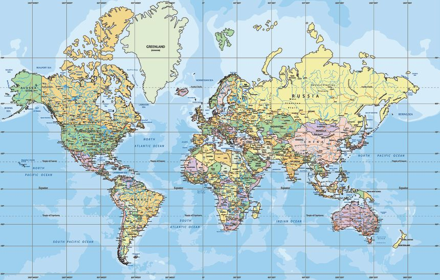
UNITED NATIONS: The United Nations General Assembly has overwhelmingly backed a resolution promoting a new world map designed to provide a more accurate representation of the relative size of continents, replacing the centuries-old Mercator projection.
The resolution, spearheaded by several African countries, was approved with 164 votes in favour, while the United States voted against and six countries abstained.
The resolution endorses the Equal Earth projection, a map designed to represent the relative surface areas of continents more accurately. It encourages UN member states to consider adopting the projection instead of the traditional Mercator map.
The Mercator projection was developed by Flemish cartographer Gerardus Mercator in 1569, primarily for maritime navigation. While it accurately preserves angles and shapes useful for navigation, it significantly distorts the relative size of landmasses, particularly toward the poles.
Speaking at the UN, Togo’s Foreign Minister Robert Dussey, whose country led the initiative, said maps influence how people understand the world.
“Maps shape our understanding of the world,” Dussey said, arguing that distorted representations can contribute to inaccurate perceptions that are passed from one generation to another.
‘A More Accurate Representation’
The Mercator projection makes northern regions appear disproportionately large, while reducing the apparent size of areas closer to the equator. As a result, Europe and North America appear significantly larger than their actual land areas, while Africa and South America appear smaller.
The Equal Earth projection, developed by a group of cartographers and launched in 2018, seeks to preserve the relative surface areas of continents while maintaining shapes that remain broadly recognizable.
Cartographer Bojan Savric previously said the projection preserves the relative areas of continents and, as far as possible, depicts their shapes as they appear on a globe.
France, which co-sponsored the UN resolution, also announced that it would move away from the Mercator projection.
French Foreign Minister Jean-Noel Barrot said the traditional map gives countries such as the United States, Russia and China disproportionate visual prominence compared with Africa, Latin America and Southeast Asia.
He also pointed to the widely noted distortion in which Greenland appears nearly as large as Africa, despite Africa being vastly larger in actual land area.
“Changing maps obviously doesn’t change the world,” Barrot said, adding that correcting a distorted representation could nevertheless be viewed as “an act of truth.”
The move comes as France seeks to strengthen relations with African countries, particularly former French colonies where ties have become increasingly strained in recent years.
